
Experience the Raahe archipelago and its historical landmarks, lightless lighthouses. In summertime, you can access the archipelago on cruise boats or by canoe – or go stand up paddling either on your own or on guided tours, or with your own or rented equipment or boat. Normally, the cruise boat charter transport season starts in May and operates all the way until October. The summer schedules for daily departures are published on the Archipelago cruises and transport website.
In winter, when the ice is firm enough, the islands can be accessed by snowmobile drawn sledge and other means, weather permitting. Skiing, walking and cycling on the frozen sea is a favourite pastime for locals too. In the brochure on excursions in the Raahe area, read more about the services available in the archipelago.
Staple town rights establish Raahe’s position as the largest harbour town in Finland
When King Gustav III finally granted staple town rights to Raahe on 7 April 1791, the town had to build a customs house for clearing goods and also meet other criteria set for staple towns. Increased commercial seafaring prompted coastal cities to systematically improve the way they marked ship routes. By the end of the 18th century, most routes leading to ports in the Gulf of Bothnia had been marked off with daymarks. In the 18th century, daymarks for sailors were set up on the islands of Tasku, Kello, Iso-Kraaseli and Kumpele off the shore of Raahe. There were four pilots serving in Raahe in 1760. Land uplift on the eastern coast of the Gulf of Bothnia also contributed to the fact that underwater rocks and shoals constantly took seafarers by surprise even when they were familiar with the routes. However, the dangerous nature of the routes prompted coastal people to hone their piloting skills. The safety of commerce and seafaring relied on their vigilance.
You’ll find a “kummeli”, or a pile of stones stacked up as a navigation mark, in the City of Raahe’s coat of arms.
Various landmarks and signposts have always guided seafarers on their way. The simplest signposts were those provided by nature: rocks, hills, trees, piles of stones. Later, people began to erect crosses on coastal cliffs or stony grounds, heap up stones and light beacons in certain locations on the shore. Such cross-shaped signposts are likely the origin of the prefix “kors-/risti” (cross) that frequently occurs in place names on the coast. For example, the oldest church of the parish of Saloinen, known already in 1329, was located in Ristikangas. An islet called Ristiluoto is located in the same region, between the islands of Lapaluoto and Iso-Kraaseli.
Daymarks had been set up on the coast of Sweden since Queen Christina’s (1632–1654) reign. Johan Månsson’s book Merikirja from 1644 contains the first reference to a daymark located on Finnish waters, on the Utö Island. Apparently, the first daymark was erected on the Tasku Island at the same time to mark the route leading to the recently founded Raahe (town of Salo in 1649).
These daymarks, or lightless lighthouses, were intended as signposts for daytime seafaring. They were the most important navigation marks in the Age of Sail, erected to mark routes leading to places such as towns. In good weather, daymarks sticking out from islands and shoals could be seen from miles away. The most common purpose of daymarks was to indicate the start or course of a route. They did not have a specific message indicated by a recurring shape or colour combination. Their ability to guide ships was based on the pilots knowing how to approach each sign and how to pass them.
Daymarks are built to withstand rough seas
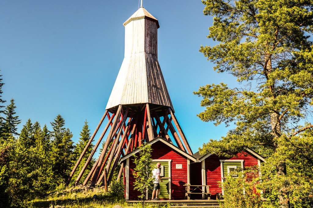
The most important thing about the shape and colour of daymarks is that they are visible on the horizon from a long distance. The most common daymarks are tower- or cone-shaped, such as the one in Iso-Kraaseli. Pyramid-shaped daymarks, such as the one in Tasku, have been built as well. Different signposts were sometimes added on top of the daymarks – such as a flag in Iso-Kraaseli, a cross in Tasku and a weather vane in Kumpele. The most frequently used colours were red, white (Iso-Kraaseli) and yellow (Tasku). Colour selection was affected by the daymark’s environment and the direction from where the vessel came. If there was a dark forest in the background of the daymark, the structure as a whole or a section of its wall surface was painted white; if there was open sea, a darker paint was used. Even under varying lighting conditions, visibility could be ensured through sharply contrasting colour combinations.
These large yet rather light structures were exposed to the elements due to their location. Generally, daymarks are equipped with items referred to as wind anchors: a timber chest, a couple of metres in height, was usually placed at the bottom of the structure and filled with stones (Tasku). Occasionally, daymarks were supported to prevent them from falling over. Their polygonal shape that tapers upwards also improved their resistance to weather (Iso-Kraaseli). The frame usually consists of heartwood as high as the daymark, and other support structures are grouped around it.
Early lighthouses were built and maintained by the bourgeoisie in local towns. The structures were designed by all kinds of people. After the founding of the Ostrobothnian navigation district, funding for construction of daymarks was provided by the state and design work was governed by state administration. Officer Albin Sjerncreutz representing a Finnish army unit during the era of autonomy was appointed as chief of the new navigation district. His task was to inspect the condition of existing navigation marks and the need for any new ones. Stjerncreutz designed all of the seven daymarks built in the Gulf of Bothnia in 1850–1857, including the ones in Iso-Kraaseli and Tasku off the shore of Raahe.
The arrival of new technology replaces wooden daymarks
Wooden daymarks gradually had to give way as lighthouses became more common. The first sea lighthouse in Ostrobothnia was completed on the Norrskär Island in Kvarken in 1846. An actual construction boom, however, did not happen until the 1870s and 1880s when some of the wooden daymarks were replaced by tile and steel towers sending out light. Since the beginning of the 20th century, daymarks became outdated and were no longer replaced after incidents such as storms or fires. The rare remaining daymarks are still marked in nautical charts, even though they are barely relevant to modern seafaring.
Buildings of cultural-historical value in our archipelago
Thirteen wooden daymarks built in the 18th and 19th century remain on the coastal strip between Siipyy and Tornio. 40 daymarks were listed in Finland’s maritime area in 1865, 18 of which were located in the Gulf of Bothnia. The daymarks, which have stood nearly unchanged in their original locations, have cultural-historical value as buildings and are an essential part of the building heritage of Finnish seafaring.
Facts about daymarks off the coast of Raahe
The Iso-Kraaseli daymark was built in 1852 according to the plans of Albin Stjerncreutz, chief of the Ostrobothnian navigation district. 25 metres above the sea level, 18 metres above the ground. Even earlier, there were a daymark and a pilot’s hut on the island. According to a sailing guidebook from 1865, a senior pilot and three pilots were on duty in the pilot’s hut. They had steering documents for all three entrance routes to Raahe. The Iso-Kraaseli daymark and the tower of Raahe’s old church were important signposts for the central route. In the Kraaseli daymark, the heartwood tree running all the way through the roof forms a two-metre pole on top of the structure, which was used as a signal pole. The daymark’s sea-facing walls are white, while the other parts are red.
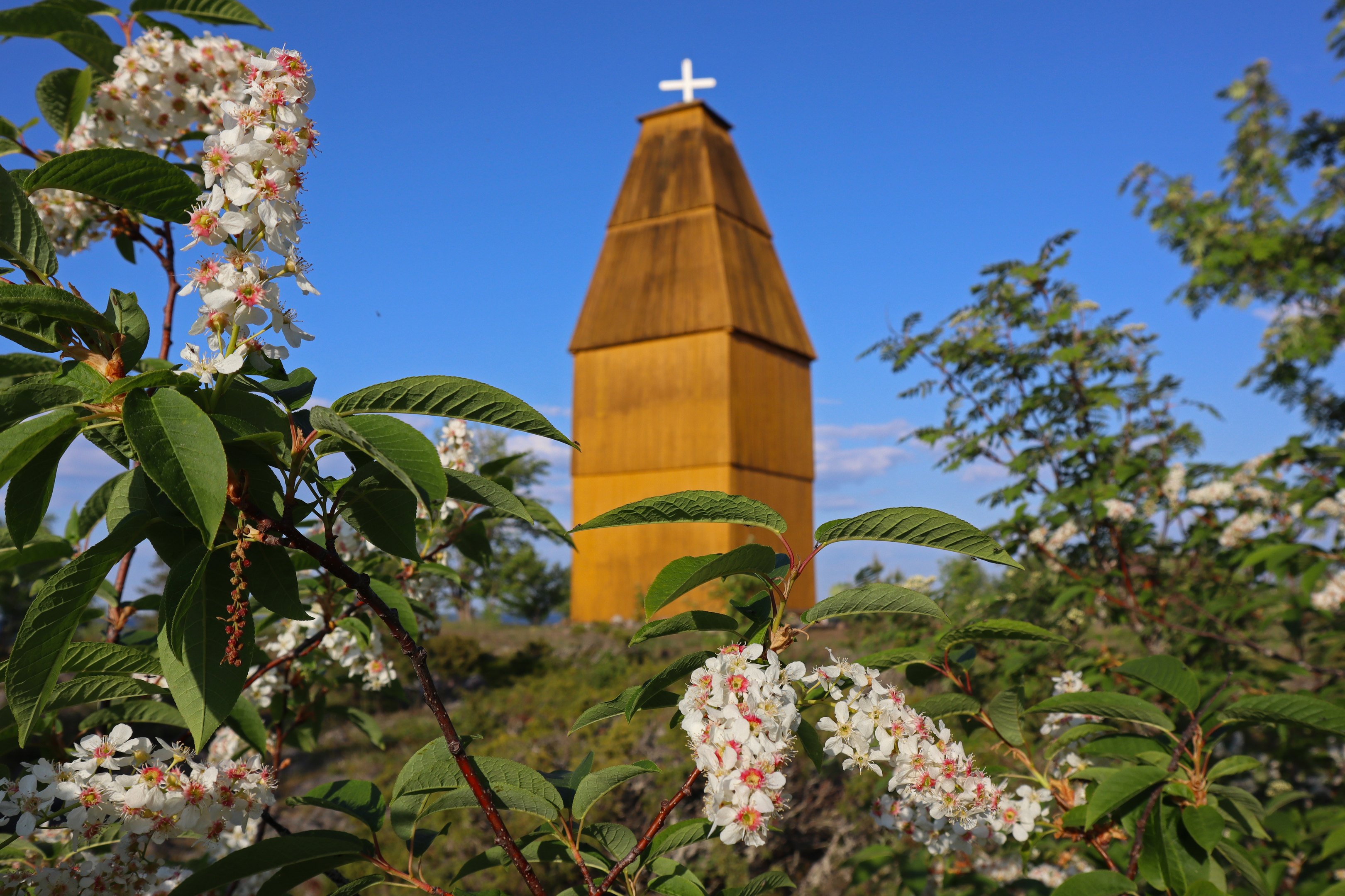
The daymark in Tasku was built in 1853. 19.2 metres above the sea level, 16.5 metres above the ground. Designed by Albin Stjerncreutz, chief of the Ostrobothnian navigation district. The original colour of the daymark was yellow. The daymark was repaired in 1866, and it is said that it was also tarred and painted with red-ochre, but was later repainted yellow in 1877. The first daymark was apparently built on the Tasku Island in the very first years following the establishment of Raahe town (1649). The layout of the daymark is square-shaped. The building resembles a church tower and the roof is pyramid-shaped, with a cross on top. The daymark was repaired in 1890, 1909 and 1914. In 1922, the daymark’s liners were renewed, the cross was replaced and a lock was added to the door, double-painted with oil paint.
Information retrieved from the archives of the Oulu pilot district in the Oulu Province Archives.
The daymark on the Kumpele Island was built in 1790. It burnt down to its foundation stones on 5 February 1961.
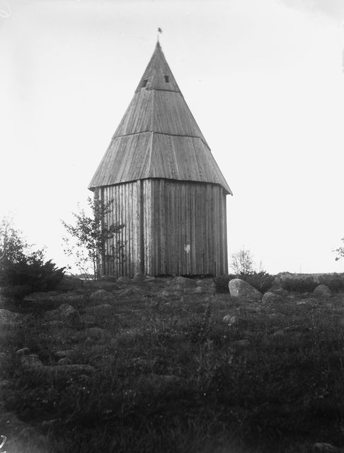
Photo taken by Samuli Paulaharju in 1923.
The article has been abridged and adapted from a text received from the Raahe Museum.